Google Earth AI
Built on years of modeling the world and Gemini’s advanced reasoning, Earth AI is helping enterprises, nonprofits and cities with everything from environmental monitoring to real-time disaster response.

Built on years of modeling the world and Gemini’s advanced reasoning, Earth AI is helping enterprises, nonprofits and cities with everything from environmental monitoring to real-time disaster response.
Featured blogs
Learn more-

blog
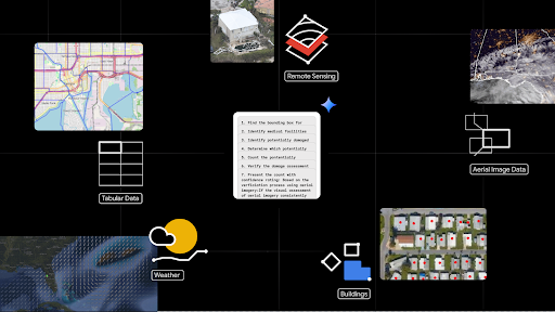
Unlocking geospatial insightsGoogle Earth AI is our family of geospatial AI models and reasoning agents that provides users with actionable insights, grounded in real-world understanding. Today, we’re sharing our latest Earth AI innovations and expanding access to these new capabilities on Google Earth and Google Cloud.
-
Blog
Geospatial reasoningWe’re leveraging geospatial foundation models and generative AI to accelerate problem solving and unlock powerful insights for crisis response, public health and climate resilience.
-
blog
Population dynamicsOur population dynamics foundation model and dataset enable us to solve a wide array of geospatial problems across health, socioeconomic and environmental tasks.
-

blog
Public healthBy combining local health data with advanced geospatial models, Google Earth AI is helping the global health community predict outbreaks, identify local vulnerabilities and deliver proactive care where it is needed most.
-

Blog
Mobility AIMobility AI uses AI advancements in measurement, simulation, and optimization to provide transportation agencies with data-driven tools for traffic management, policymaking and urban monitoring.
-

blog
S2VecWe’re applying S2Vec, a self-supervised framework that transforms complex geospatial data into general-purpose embeddings to predict socioeconomic and environmental patterns across the globe.
-

blog
Flash floodsWe’re expanding our global flood forecasting coverage with the roll-out of flash flood predictions in urban areas. Using a novel AI training method based on news data, we provide up to 24 hours advance notice for these rapid-onset events.
-

blog
SpeciesNetWe’re advancing global research and conservation with SpeciesNet, an open-source AI tool that automatically identifies species in camera trap images.
-

blog
NeuralGCMNeuralGCM combines physics-based modeling and a neural network trained on NASA precipitation observations to simulate global precipitation more accurately than other methods, particularly for capturing the daily precipitation cycle and extreme events.
-

blog
Hard-braking eventsWe’re using hard-braking event (HBE) data from Android Auto to identify road segments with higher crash risk, offering a leading measure for more proactive road safety assessment.
-

blog
DeforestationNatural Forests of the World 2020 is an AI-powered map that distinguishes natural forests from other tree cover. This critical baseline helps governments, companies, and communities meet deforestation-free goals and protect ecosystems.
-

BLOG
Nature restorationWe’re using high-resolution deep learning to reveal fine-scale ecological features like hedgerows and copses. This precise data provides a new pathway to address climate and biodiversity crises without compromising food security.