
Zooming in: Efficient regional environmental risk assessment with generative AI
June 5, 2025
Ignacio Lopez-Gomez, Research Scientist, and Tyler Russell, Technical Program Manager, Google Research
We present a new method that combines physics-based climate modeling with artificial intelligence to create detailed estimates of regional environmental risk. This approach enables a more comprehensive assessment of uncertainties in future environmental outlooks than existing techniques.
Quick links
Earth system models represent our best tool to predict and prepare for future changes to Earth’s environment. However, the immense computational cost of running these models at high resolution limits their ability to make regional projections at fine scales. Indeed, a typical limiting scale for these models is comparable in size to the island of Hawai’i (~100 km). Obtaining more granular projections, for instance at the city level (~10 km), is critical for planning everything from farming strategies and water management to protecting communities from floods, heatwaves, and wildfires.
To address this need, we are excited to announce a novel generative AI method that bridges the resolution gap between Earth system models and downstream users’ needs. Published in the Proceedings of the National Academy of Sciences, we present a dynamical-generative downscaling method that applies probabilistic diffusion models — a powerful class of generative AI capable of learning complex data distributions — to the output of well-established physics-based models to translate global climate projections into local (~10 km) assessments of present and future environmental risk. Dynamical-generative downscaling produces detailed local environmental risk assessments at a small fraction of the cost of existing state-of-the-art techniques, which are too computationally expensive to apply to the wealth of climate projection data that is now available.
From global projections to regional environmental risk
To capture local changes in environmental conditions at resolutions of 10 km or higher, scientists typically use a technique called "dynamical downscaling". This involves taking coarse information from global Earth system models and running much finer-grained simulations with regional climate models (RCMs) over a specific area. Think of it like using a magnifying glass on a global map.

Downscaling methods increase the resolution of climate projections over limited-area regions of the Earth. This enables us to understand the effect of topography and regional processes on weather extremes. Rendering generated by Imagen 3.
While dynamical downscaling provides the most physically realistic local projections, it has a major drawback: it is computationally expensive. Running these detailed simulations takes substantial computing power, making it impractical to downscale the many different climate projections needed to fully capture the range of possible future environmental conditions. Faster statistical downscaling methods exist, but they often struggle to accurately capture complex local weather patterns (especially extreme events) or to generalize reliably to future conditions for which they were not trained.
A more efficient approach: Physics meets generative AI
Instead, we propose to combine the physical realism of dynamical downscaling with the speed and pattern-recognition power of artificial intelligence. The dynamical-generative downscaling process works in two steps:
- Physics-based first pass: First, a regional climate model downscales global Earth system data, but only to an intermediate, and still coarse, resolution (e.g., 50 km). This step is much cheaper computationally than going straight to very high resolution, but crucially, it translates the varied outputs of different global models into a common grid and physical representation of the Earth. This process sets the stage for efficient learning by AI systems.
- AI adds the fine details: Next, a newly developed generative AI system, the Regional Residual Diffusion-based Downscaling model (“R2D2”), takes over. Trained on examples of high-resolution weather data, R2D2 learns to add realistic, fine-scale details (like the effects of complex terrain) to the intermediate-resolution output, efficiently bringing it up to the target high resolution (typically less than 10 km). The model focuses on learning the difference, or "residual", between the intermediate and high-resolution fields, which makes the learning task easier and improves generalization to unseen environmental conditions.
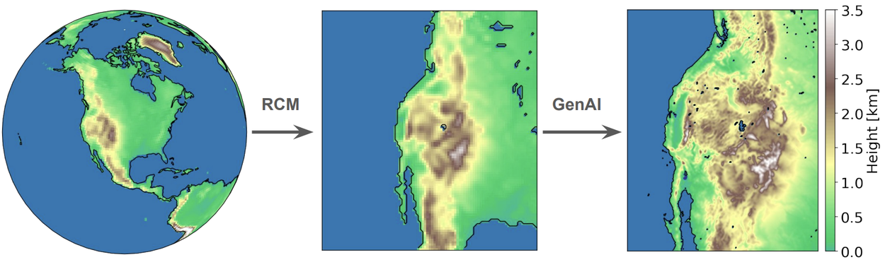
Dynamical-generative downscaling extracts regional climate information from Earth system models in a two-step process. A regional climate model (RCM) provides a physics-based first pass, and generative AI adds the finer details.
This hybrid approach leverages the strengths of both methods: the RCM provides a physically grounded base and handles the diversity of global models, while the AI excels at efficiently generating the high-resolution details and capturing the full range of regional environmental conditions. Importantly, the R2D2 model only needs training data from one dynamically downscaled Earth system model to learn how to effectively downscale outputs originating from different Earth system models. This enables our model to amortize the training cost when applied to large ensembles of climate projections.
Efficient and reliable regional climate projections
We trained and evaluated our model using the Western United States Dynamically Downscaled Dataset (WUS-D3). WUS-D3 contains an ensemble of regional climate projections over the Western United States, downscaled to 9 km resolution using the "gold standard", but expensive dynamical downscaling WRF model. We trained our model on a single WUS-D3 climate projection, and evaluated its skill by downscaling 7 additional climate projections from the WUS-D3 ensemble. We compared the results against the computationally expensive dynamical downscaling, our target, and two popular statistical downscaling methods: BCSD and STAR-ESDM. The results were compelling:
- Higher accuracy: Dynamical-generative downscaling reduces fine-scale errors by over 40% compared to statistical methods across various weather variables like temperature, precipitation, relative humidity, and wind speed, as measured by the continuous ranked probability score (CRPS). It also effectively corrects systematic biases in the coarse-resolution climate simulations, critical for accurate environmental risk assessment of coastal and mountainous regions.
- Realistic weather patterns: The AI-generated results capture realistic spatial patterns, correlations between different weather variables (like wind speed and direction, or heat and humidity), and importantly, the likelihood of compound extreme events (like concurrent heat and drought). Identifying spatial patterns and correlations is important for downstream applications in hydrology, energy forecasting, or natural hazard risk assessment.
- Better uncertainty estimates: By downscaling large ensembles of climate projections, our framework provides a more comprehensive picture of the range of potential future environmental conditions than could be achieved by either the statistical methods or by dynamically downscaling only a smaller subset of Earth system models. This greater reliability is crucial for robust risk assessment. For example, dynamical-generative downscaling reduces the error in projections of extreme summer heat and winter precipitation by over 20% and 10% compared to those baselines, respectively, as measured by the mean absolute error in the 99th climatological percentile.
- Capturing regional extremes: The method shows remarkable skill in capturing complex environmental risks due to regional phenomena, e.g., wildfire risk due to Santa Ana winds in Southern California. Projecting wildfire risk requires the accurate detection of fine-scale correlations between temperature, humidity, and wind extremes. Statistical downscaling methods, such as BCSD and STAR-ESDM, struggle at capturing granular correlations between meteorological fields, underestimating the risk of concurrent hazards.

A comparison of fine-scale prediction errors (a–c) and energy spectra (d–f) between our model (R2D2) and the statistical downscaling baselines (BCSD, STAR-ESDM) for ensemble projections of wind speed (left), relative humidity (center), and temperature (right). The new method shows lower error (CRPS) and more realistic weather patterns, as measured by the alignment of the R2D2 and target energy spectra. The bottom panels compare the covariation of hot and dry summer extremes (g–i) and wind extremes in the fall (j–l).

Model projections of wildfire risk during a strong Santa Ana wind event in Southern California under environmental conditions taken from an end-of-century climate projection. Wildfire risk is measured by the weather component of the Santa Ana Wildfire Threat Index. The dynamical-generative approach (a) captures wildfire risk well compared to the more expensive dynamical downscaling method (b). Statistical downscaling methods such as STAR-ESDM (c) and BCSD (d) often struggle to capture the magnitude and spatial structure of such compound risks.
Why this breakthrough matters
Dynamical-generative downscaling represents a significant step towards obtaining comprehensive future regional climate projections at actionable scales below 10 km. It makes downscaling large ensembles of Earth system models computationally feasible — our study estimates computational cost savings of 85% for the 8-model ensemble tested, a figure that would increase for larger ensembles. The fast and efficient AI inference step is similar to how Google’s SEEDS and GenCast weather forecasting models operate, enabling a thorough assessment of regional environmental risk.
By providing more accurate and probabilistically complete regional climate projections at a fraction of the computational cost, dynamical-generative downscaling can dramatically improve environmental risk assessments. This enables better-informed decisions for adaptation and resilience policies across vital sectors like agriculture, water resource management, energy infrastructure, and natural hazard preparedness.
Acknowledgements
We would like to thank our co-authors Zhong Yi Wan, Leonardo Zepeda-Núñez, Tapio Schneider, John Anderson, and Fei Sha. We would also like to acknowledge Stephan Hoyer, Lizao Li, Alex Hall, and Stefan Rahimi for insightful comments on our work.
Quick links
Other posts of interest
-

April 3, 2026
Evaluating alignment of behavioral dispositions in LLMs- Generative AI ·
- Human-Computer Interaction and Visualization ·
- Machine Intelligence
-

March 24, 2026
TurboQuant: Redefining AI efficiency with extreme compression- Algorithms & Theory ·
- Generative AI ·
- Machine Intelligence
-

March 12, 2026
Protecting cities with AI-driven flash flood forecasting- Climate & Sustainability ·
- Earth AI ·
- Generative AI ·
- Open Source Models & Datasets


