NeuralGCM harnesses AI to better simulate long-range global precipitation
January 12, 2026
Janni Yuval, Research Scientist, Google Research
NeuralGCM combines physics-based modeling and a neural network trained on NASA precipitation observations to simulate global precipitation more accurately than other methods, particularly for capturing the daily precipitation cycle and extreme events.
Quick links
Precipitation remains one of the trickiest tasks for global-scale weather and climate models. That’s because exactly where, when and how much precipitation will fall depends on a series of events happening at scales that are typically below the model resolution. Simulating precipitation is especially challenging for extreme events and over long periods of time. Whether it’s farmers knowing which day to plant seeds to optimize their harvest, or city planners knowing how to prepare for a 100-year storm, precipitation forecasts are some of the most relevant for humans.
Last year, we introduced our open-sourced hybrid atmospheric model NeuralGCM, which combines machine learning (ML) and physics to run fast, efficient and accurate global atmospheric simulations. In the 2024 paper, NeuralGCM generated more accurate 2–15 day weather forecasts and reproduced historical temperatures over four decades with greater precision than traditional atmospheric models, marking a significant step towards developing more accessible climate models.
Now in “Neural general circulation models for modeling precipitation”, published in Science Advances, we describe how NeuralGCM was trained on satellite-based precipitation observations to achieve improved simulations of precipitation. Notably, at the current resolution of 280 km, we see improvements against a leading operational model for medium-range weather forecasting (up to 15 days) and against atmospheric models used for multi-decadal climate simulations. We find NeuralGCM more accurately reproduces average precipitation, precipitation extremes — with major improvements for the top 0.1% of rainfall — and the daily weather cycle.
NeuralGCM is part of a broader effort to advance weather and climate science, within Earth AI. As a hybrid model that combines physics and AI to tackle longer-range questions, it complements other AI-only weather models like the recently introduced WeatherNext 2 update from our Google colleagues.
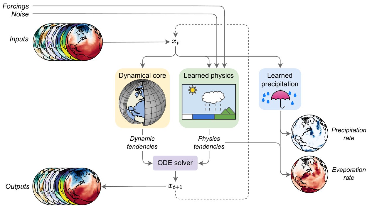
NeuralGCM uses a hybrid framework that combines a traditional fluid dynamics solver (gray sphere) for large-scale processes with AI neural networks (cartoon box and umbrella) for small-scale physics, like clouds, radiation and precipitation.
Clouds’ diversity and fleeting nature pose challenges
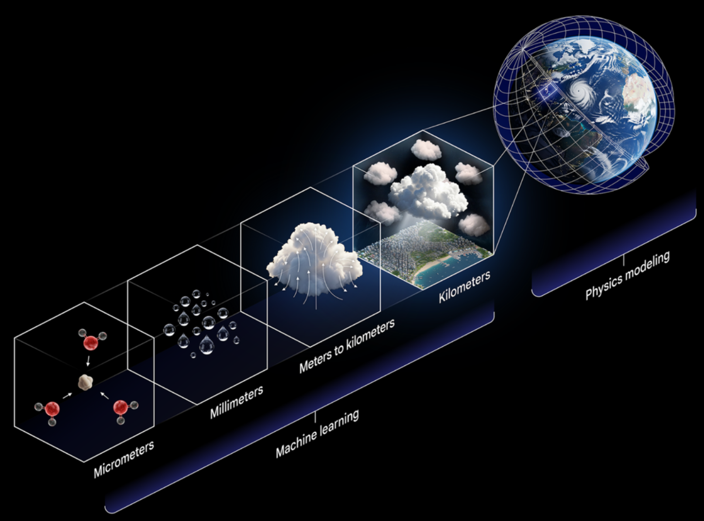
To simulate precipitation, we must go to its source: clouds. Clouds can exist at scales smaller than 100 meters, the size of an athletic field — far below the kilometers-scale resolution of global weather models, or the tens-of-kilometers–scale resolution of global climate models. Clouds come in different types, change quickly, and the intricate physics happening at even smaller scales can generate water droplets or ice crystals. All this complexity is impossible for large-scale models to resolve or calculate.
To account for the effect of small-scale atmospheric processes like cloud formation on the climate, models use approximations, called parameterizations, which are based on other variables. Rather than depending on these parameterizations, NeuralGCM uses a neural network to learn the effects of such small-scale events directly from existing weather data.
We improved the representation of precipitation in this version of our model by training the ML portion of NeuralGCM directly on satellite-based precipitation observations. The initial offering of NeuralGCM was, like most ML weather models, trained on recreations of previous atmospheric conditions, i.e., reanalyses, that combine physics-based models with observations to fill in gaps in observational data. But the physics of clouds is so complex that even reanalyses struggle to get precipitation right. Training on output from reanalyses means reproducing their weaknesses, for example, on precipitation extremes and the daily cycle.
Instead, we trained the precipitation part of NeuralGCM directly on NASA satellite-based precipitation observations spanning from 2001 to 2018. NeuralGCM’s differential dynamical core infrastructure allowed us to train it on satellite observations. Previous hybrid models that combine physics and AI could only use output from high-fidelity simulations or reanalysis data. By training the AI component of NeuralGCM directly on high-quality satellite observations instead of relying on reanalyses, we are effectively finding a better, machine-learned parameterization for precipitation.

Global weather and climate models divide Earth into a grid of boxes many kilometers across. But precipitation depends on smaller scales: water molecules that aggregate around a particle, forming droplets, which condense inside clouds and eventually precipitate out. Traditional models estimate the impact of small-scale processes with equations based on other variables (parameterizations). NeuralGCM instead uses those other variables with an ML model trained directly on satellite precipitation observations to better simulate global precipitation.
Forecasting precipitation over the next 15 days
We evaluated NeuralGCM’s performance on two-week forecasts using WeatherBench 2, comparing it against a leading physics-based model from the European Centre for Medium-range Weather Forecasts (ECMWF). In tests using forecasts starting at noon and midnight on each day in 2020 (data was not used during training), NeuralGCM significantly outperformed the ECMWF model at low resolution across most averaged measures of precipitation. This included both 24-hour and 6-hour accumulated precipitation for all 15 forecast days. The advantage remained significant over land masses, which are critical for humans and ecosystems.

The graph on the left compares 24-hour accumulated precipitation forecasts from NeuralGCM (blue line) and the ECMWF medium-range forecast (orange line). Performance was measured against IMERG satellite observations using the continuous ranked probability score, a measure of forecast performance. NeuralGCM ranks lower, which is better, across all 15 forecast days. The maps on the right show the spatial distribution of that score two days into the forecast.
Knowing when and where precipitation is going to fall helps communities manage flooding and drought, use irrigation resources most efficiently, plan events and protect public safety. While NeuralGCM’s current resolution of 280 kilometers is too coarse for operational forecasts, these results suggest there’s potential to leverage this technique at smaller scales to improve the tools used for operational forecasts.
Precipitation patterns over years to decades
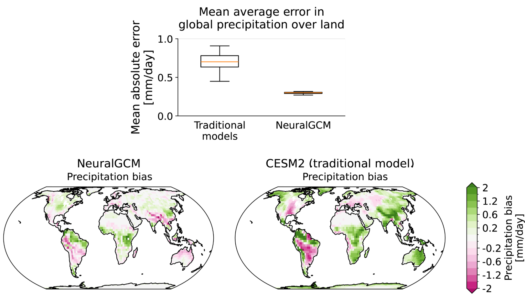
Over longer timescales, from years to decades, understanding average precipitation patterns can help with flood control, crop planning, and managing drinking water supplies. Given NeuralGCM’s 280 kilometer resolution, our current focus extends to larger scales of geography and time. When comparing multi-year runs of NeuralGCM against leading global atmospheric models used to study climate, NeuralGCM had an average mean error of less than half a millimeter per day. This represents a 40% average error reduction compared to the leading tools used in the latest Intergovernmental Panel on Climate Change report, with an even bigger improvement over land.

The box plot (top) shows the mean absolute error in precipitation for traditional models in the Atmospheric Model Intercomparison Project compared to NeuralGCM trained on satellite precipitation observations. The errors are measured in millimeters per day over land from 2002 to 2014 compared to IMERG satellite precipitation observations. NeuralGCM had an average error (orange line) of 0.3 millimeters per day over land, less than half that of the leading tools. The maps show the spatial distribution of precipitation bias for NeuralGCM and the Community Earth System Model 2.
NeuralGCM also showed major improvements for extreme precipitation, the top 0.1% of rainfall at a given location. Extreme events are some of the hardest to reproduce because fewer previous examples exist, and the parameterizations that physics-based models use to estimate precipitation often overrepresent light events while underrepresenting heavy events — known as the drizzle problem. NeuralGCM more accurately captured the intensity of precipitation events, especially of heavy precipitation, in simulations from 2002 to 2014. Capturing these most extreme, damaging precipitation events is an important step for applications ranging from climate science to public safety.

The top graph shows tropical precipitation rates up to more than 160 mm/day from 2002 to 2014. NeuralGCM (blue), trained on satellite precipitation observations, closely matches the observed frequency of rain events from IMERG (dotted line). The ERA5 reanalysis (orange) and the IPSL model (green) overestimate light events and underestimate heavy precipitation. Maps show precipitation bias for the heaviest rainfall day of the year. The map colors show that NeuralGCM is less likely to underestimate (pink) or overestimate (green) heavy precipitation compared to the IPSL model.
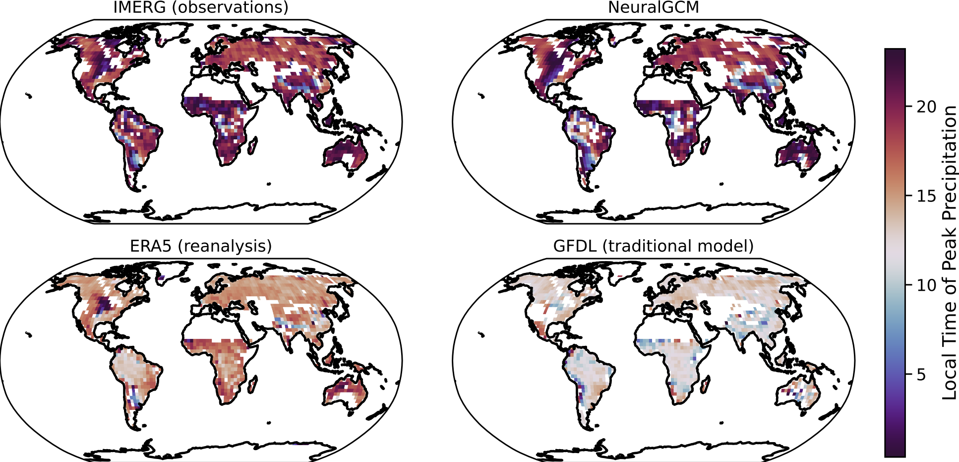
Finally, we also looked at how precipitation falls during a single day of the long-range climate simulations. The Amazon rainforest, for example, has a very strong daily cycle. In summer you can expect heavy rains in the afternoon. While today’s climate models tend to have rain fall several hours earlier than in the real world, NeuralGCM more accurately reproduces the timing and amount of peak daily precipitation, particularly over land and in summer. The focus is on precipitation over land, where the diurnal cycle is stronger and where traditional models struggle, and in summer, a standard climate science evaluation period because of its marked diurnal cycle. Capturing when precipitation falls during the day matters at a large scale for ecosystems, weather systems and hydrology.

NeuralGCM does better than other tools at reproducing the time of day of peak precipitation, represented here by the map colors. IMERG satellite observations and NeuralGCM have similar colors for the timing of peak precipitation, often late in the day. The ERA5 reanalysis and NOAA’s Geophysical Fluid Dynamics Laboratory model have lighter colors, meaning peak precipitation happens earlier in the day in those models, around midday or early afternoon.
Looking ahead
We believe this is a step forward for large-scale precipitation forecasts and simulations, and we already have early support in the real world. A partnership between the University of Chicago and the Indian Ministry of Agriculture and Farmers’ Welfare used NeuralGCM for a pilot program using AI-based forecasts to predict the onset of the monsoon season. The team selected NeuralGCM and one other model after rigorous testing, and built a forecasting tool that was deployed for the first time this past summer.
Since introducing NeuralGCM we have made everything available as open-source code on which we hope people can build. This precipitation model is also being openly released to the extended community. Ultimately our hope is that these efforts will bring us one step closer to accurate long-term projections of future precipitation, especially under climate change.
To learn more about geospatial platforms and AI work at Google, check out Google Earth, Earth Engine, AlphaEarth Foundations, and Earth AI.
Acknowledgments
We would like to acknowledge the NeuralGCM Team (Dmitrii Kochkov, Ian Langmore and Stephan Hoyer). Thanks also to Hannah Hickey and Elise Kleeman for assistance with this blog post, and to Lizzie Dorfman, Michael Brenner and John Platt for their support and leadership.
Quick links
Other posts of interest
-

March 12, 2026
Protecting cities with AI-driven flash flood forecasting- Climate & Sustainability ·
- Earth AI ·
- Generative AI ·
- Open Source Models & Datasets
-
March 12, 2026
Introducing Groundsource: Turning news reports into data with Gemini- Climate & Sustainability ·
- Generative AI ·
- Natural Language Processing ·
- Open Source Models & Datasets
-

March 11, 2026
Exploring the feasibility of conversational diagnostic AI in a real-world clinical study- Generative AI ·
- Health & Bioscience ·
- Machine Intelligence