MetNet-3: A state-of-the-art neural weather model available in Google products
November 1, 2023
Posted by Samier Merchant, Google Research, and Nal Kalchbrenner, Google DeepMind
Quick links
Forecasting weather variables such as precipitation, temperature, and wind is key to numerous aspects of society, from daily planning and transportation to energy production. As we continue to see more extreme weather events such as floods, droughts, and heat waves, accurate forecasts can be essential to preparing for and mitigating their effects. The first 24 hours into the future are especially important as they are both highly predictable and actionable, which can help people make informed decisions in a timely manner and stay safe.
Today we present a new weather model called MetNet-3, developed by Google Research and Google DeepMind. Building on the earlier MetNet and MetNet-2 models, MetNet-3 provides high resolution predictions up to 24 hours ahead for a larger set of core variables, including precipitation, surface temperature, wind speed and direction, and dew point. MetNet-3 creates a temporally smooth and highly granular forecast, with lead time intervals of 2 minutes and spatial resolutions of 1 to 4 kilometers. MetNet-3 achieves strong performance compared to traditional methods, outperforming the best single- and multi-member physics-based numerical weather prediction (NWP) models — such as High-Resolution Rapid Refresh (HRRR) and ensemble forecast suite (ENS) — for multiple regions up to 24 hours ahead.
Finally, we’ve integrated MetNet-3’s capabilities across various Google products and technologies where weather is relevant. Currently available in the contiguous United States and parts of Europe with a focus on 12 hour precipitation forecasts, MetNet-3 is helping bring accurate and reliable weather information to people in multiple countries and languages.
 |
 |
| MetNet-3 precipitation output summarized into actionable forecasts in Google Search on mobile. |
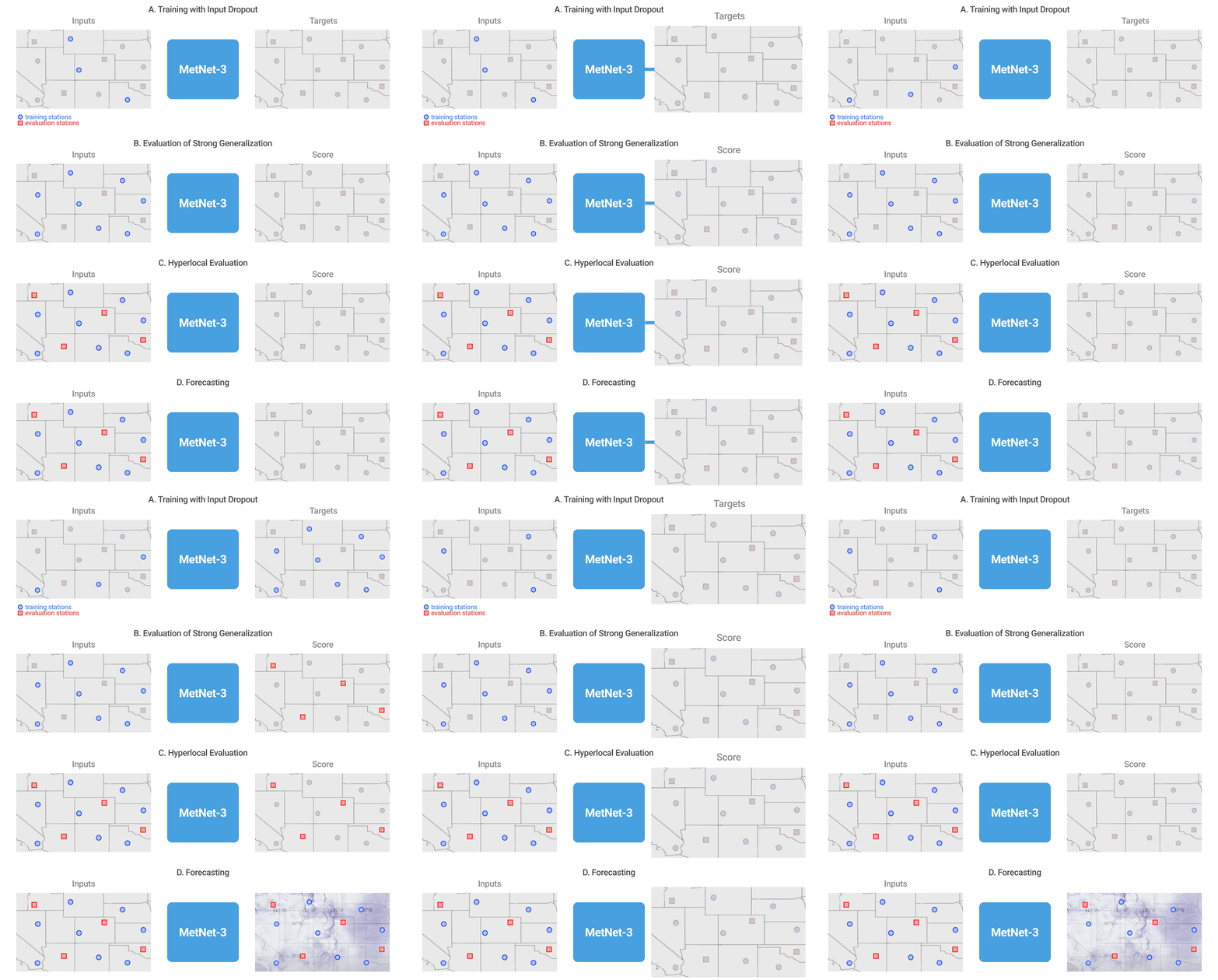
Densification of sparse observations
Many recent machine learning weather models use the atmospheric state generated by traditional methods (e.g., data assimilation from NWPs) as the primary starting point to build forecasts. In contrast, a defining feature of the MetNet models has been to use direct observations of the atmosphere for training and evaluation. The advantage of direct observations is that they often have higher fidelity and resolution. However, direct observations come from a large variety of sensors at different altitudes, including weather stations at the surface level and satellites in orbit, and can be of varying degrees of sparsity. For example, precipitation estimates derived from radar such as NOAA’s Multi-Radar/Multi-Sensor System (MRMS) are relatively dense images, whereas weather stations located on the ground that provide measurements for variables such as temperature and wind are mere points spread over a region.
In addition to the data sources used in previous MetNet models, MetNet-3 includes point measurements from weather stations as both inputs and targets with the goal of making a forecast at all locations. To this end, MetNet-3’s key innovation is a technique called densification, which merges the traditional two-step process of data assimilation and simulation found in physics-based models into a single pass through the neural network. The main components of densification are illustrated below. Although the densification technique applies to a specific stream of data individually, the resulting densified forecast benefits from all the other input streams that go into MetNet-3, including topographical, satellite, radar, and NWP analysis features. No NWP forecasts are included in MetNet-3’s default inputs.
High resolution in space and time
A central advantage of using direct observations is their high spatial and temporal resolution. For example, weather stations and ground radar stations provide measurements every few minutes at specific points and at 1 km resolutions, respectively; this is in stark contrast with the assimilation state from the state-of-the-art model ENS, which is generated every 6 hours at a resolution of 9 km with hour-by-hour forecasts. To handle such a high resolution, MetNet-3 preserves another of the defining features of this series of models, lead time conditioning. The lead time of the forecast in minutes is directly given as input to the neural network. This allows MetNet-3 to efficiently model the high temporal frequency of the observations for intervals as brief as 2 minutes. Densification combined with lead time conditioning and high resolution direct observations produces a fully dense 24 hour forecast with a temporal resolution of 2 minutes, while learning from just 1,000 points from the One Minute Observation (OMO) network of weather stations spread across the United States.
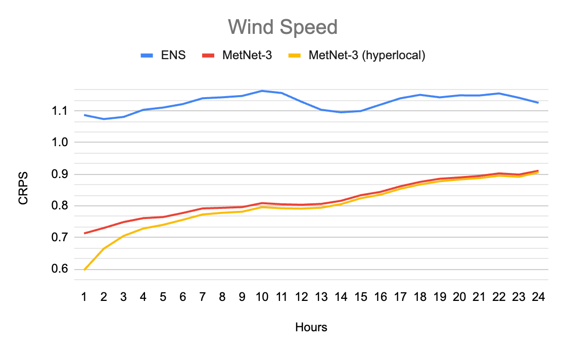
MetNet-3 predicts a marginal multinomial probability distribution for each output variable and each location that provides rich information beyond just the mean. This allows us to compare the probabilistic outputs of MetNet-3 with the outputs of advanced probabilistic ensemble NWP models, including the ensemble forecast ENS from the European Centre for Medium-Range Weather Forecasts and the High Resolution Ensemble Forecast (HREF) from the National Oceanic and Atmospheric Administration of the US. Due to the probabilistic nature of the outputs of both models, we are able to compute scores such as the Continuous Ranked Probability Score (CRPS). The following graphics highlight densification results and illustrate that MetNet’s forecasts are not only of much higher resolution, but are also more accurate when evaluated at the overlapping lead times.
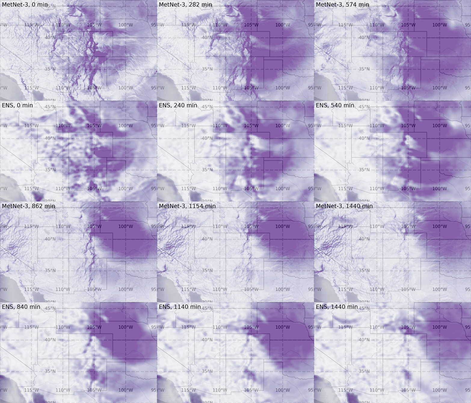 |
| Top: MetNet-3’s forecast of wind speed for each 2 minutes over the future 24 hours with a spatial resolution of 4km. Bottom: ENS’s hourly forecast with a spatial resolution of 18 km. The two distinct regimes in spatial structure are primarily driven by the presence of the Colorado mountain ranges. Darker corresponds to higher wind speed. More samples available here: 1, 2, 3, 4. |
In contrast to weather station variables, precipitation estimates are more dense as they come from ground radar. MetNet-3’s modeling of precipitation is similar to that of MetNet-1 and 2, but extends the high resolution precipitation forecasts with a 1km spatial granularity to the same 24 hours of lead time as the other variables, as shown in the animation below. MetNet-3’s performance on precipitation achieves a better CRPS value than ENS’s throughout the 24 hour range.
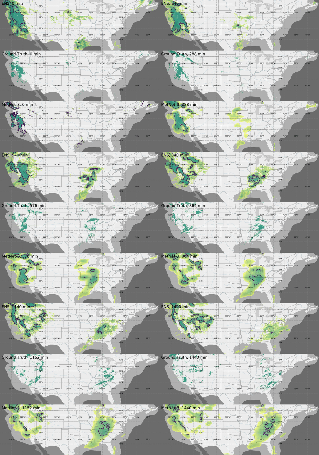 |
| Case study for Thu Jan 17 2019 00:00 UTC showing the probability of instantaneous precipitation rate being above 1 mm/h on CONUS. Darker corresponds to a higher probability value. The maps also show the prediction threshold when optimized towards Critical Success Index CSI (dark blue contours). This specific case study shows the formation of a new large precipitation pattern in the central US; it is not just forecasting of existing patterns. Top: ENS’s hourly forecast. Center: Ground truth, source NOAA’s MRMS. Bottom: Probability map as predicted by MetNet-3. Native resolution available here. |
 |
| Performance comparison between MetNet-3 and NWP baseline for instantaneous precipitation rate on CRPS (lower is better). |
Delivering realtime ML forecasts
Training and evaluating a weather forecasting model like MetNet-3 on historical data is only a part of the process of delivering ML-powered forecasts to users. There are many considerations when developing a real-time ML system for weather forecasting, such as ingesting real-time input data from multiple distinct sources, running inference, implementing real-time validation of outputs, building insights from the rich output of the model that lead to an intuitive user experience, and serving the results at Google scale — all on a continuous cycle, refreshed every few minutes.
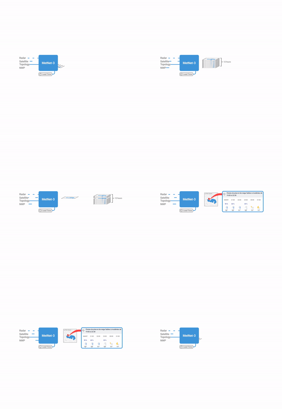
We developed such a real-time system that is capable of producing a precipitation forecast every few minutes for the entire contiguous United States and for 27 countries in Europe for a lead time of up to 12 hours.
 |
| Illustration of the process of generating precipitation forecasts using MetNet-3. |
The system's uniqueness stems from its use of near-continuous inference, which allows the model to constantly create full forecasts based on incoming data streams. This mode of inference is different from traditional inference systems, and is necessary due to the distinct characteristics of the incoming data. The model takes in various data sources as input, such as radar, satellite, and numerical weather prediction assimilations. Each of these inputs has a different refresh frequency and spatial and temporal resolution. Some data sources, such as weather observations and radar, have characteristics similar to a continuous stream of data, while others, such as NWP assimilations, are similar to batches of data. The system is able to align all of these data sources spatially and temporally, allowing the model to create an updated understanding of the next 12 hours of precipitation at a very high cadence.
With the above process, the model is able to predict arbitrary discrete probability distributions. We developed novel techniques to transform this dense output space into user-friendly information that enables rich experiences throughout Google products and technologies.
Weather features in Google products
People around the world rely on Google every day to provide helpful, timely, and accurate information about the weather. This information is used for a variety of purposes, such as planning outdoor activities, packing for trips, and staying safe during severe weather events.
The state-of-the-art accuracy, high temporal and spatial resolution, and probabilistic nature of MetNet-3 makes it possible to create unique hyperlocal weather insights. For the contiguous United States and Europe, MetNet-3 is operational and produces real-time 12 hour precipitation forecasts that are now served across Google products and technologies where weather is relevant, such as Search. The rich output from the model is synthesized into actionable information and instantly served to millions of users.
For example, a user who searches for weather information for a precise location from their mobile device will receive highly localized precipitation forecast data, including timeline graphs with granular minute breakdowns depending on the product.
 |
| MetNet-3 precipitation output in weather on the Google app on Android (left) and mobile web Search (right). |
Conclusion
MetNet-3 is a new deep learning model for weather forecasting that outperforms state-of-the-art physics-based models for 24-hour forecasts of a core set of weather variables. It has the potential to create new possibilities for weather forecasting and to improve the safety and efficiency of many activities, such as transportation, agriculture, and energy production. MetNet-3 is operational and its forecasts are served across several Google products where weather is relevant.
Acknowledgements
Many people were involved in the development of this effort. We would like to especially thank those from Google DeepMind (Di Li, Jeremiah Harmsen, Lasse Espeholt, Marcin Andrychowicz, Zack Ontiveros), Google Research (Aaron Bell, Akib Uddin, Alex Merose, Carla Bromberg, Fred Zyda, Isalo Montacute, Jared Sisk, Jason Hickey, Luke Barrington, Mark Young, Maya Tohidi, Natalie Williams, Pramod Gupta, Shreya Agrawal, Thomas Turnbull, Tom Small, Tyler Russell), and Google Search (Agustin Pesciallo, Bill Myers, Danny Cheresnick, Jonathan Karsh, Lior Cohen, Maca Piombi, Maia Diamant, Max Kamenetsky, Maya Ekron, Mor Schlesinger, Neta Gefen-Doron, Nofar Peled Levi, Ofer Lehr, Or Hillel, Rotem Wertman, Tamar Shevach,Vinay Ruelius Shah, Yechie Labai).
-
Labels:
- Machine Intelligence
