
From research to climate resilience
June 24, 2025
Yossi Matias, Vice President & Head of Google Research
Google Research is driving AI breakthroughs to help communities bolster their resilience to climate-related threats.
At Google Research, we're driven by exploring the art of the possible. Our research impacts products, businesses, scientific discovery, and society. Today, the opportunity to help solve seemingly impossible problems with breakthrough research is greater than ever, as is the opportunity to translate this research into real-world impact.
I'm excited to share how we're advancing research and harnessing tech innovation to help build more resilience, tackling the urgent challenges of climate crises, such as wildfires, floods, extreme weather, and cyclones. Can we deliver timely, reliable predictions of these threats, helping people stay safe and communities build resilience?
Our work with AI over the past years, advancing climate science and tackling these difficult problems, is already making a tangible difference. It clearly demonstrates AI’s potential to build towards better climate resilience.

From impossible to global scale: AI-powered flood forecasting
A few years ago, providing accurate, reliable flood predictions was widely considered an impossible challenge. Today, Google Research’s groundbreaking global hydrological AI model, published in Nature, enables us to accurately forecast riverine floods around the world up to seven days in advance. Our forecasts are available on Google’s Flood Hub platform and cover over 700 million people across more than 100 countries worldwide, empowering governments and local communities to protect lives and livelihoods.
We’re also providing researchers and experts with expanded coverage via an API as well as an expert data layer on Flood Hub. We’ve employed AI to analyze historical data and create “virtual gauges” for locations where data is scarce and physical gauges are not available. This significantly expands our coverage to data-scarce regions across 150 countries, addressing the need, raised by our partners, for greater information in these regions, which are particularly vulnerable. We’re also working with the WMO and meteorological services in other countries, including the Czech Republic, Nigeria, Uruguay, and Vietnam, on efforts to scale flood forecasting globally, further enhancing community resilience worldwide.
Improving the lead time and accuracy of cyclone forecasts
Cyclones — also known as typhoons or hurricanes — devastate communities and endanger lives. In the last 50 years, they have caused 1.4 trillion dollars in economic losses. Advanced warning could make a tremendous difference, but it is difficult to predict whether oceanic storms will become dangerous cyclones, where they might make landfall, and what the impact will be. For decades, scientists have relied on supercomputers to simulate the laws of physics to estimate the future path, intensity and size of these storms. Now Google DeepMind and Google Research teams are exploring AI’s potential to improve how we predict and prepare for cyclones. We can currently predict existence, track, intensity, size, and structure, generating up to 50 possible scenarios as far as 15 days in advance. It’s still early days and we're working with experts around the world, including partners in academia, government agencies, and non-profit organizations, to refine and expand the impact of our work.

Earlier this month we announced Weather Lab, an interactive website where we are sharing ongoing research, making our newest and most accurate weather models available to experts and the public. We also announced a partnership with the US National Hurricane Center, who will be leveraging these experimental models this summer throughout the Atlantic Hurricane Season. We hope this data can help improve NHC forecasts and provide earlier and more accurate warnings for hazards linked to tropical cyclones.
Nowcasting: Improving access to reliable, real-time weather information
We’re applying AI to improve forecasts for everyday weather, too. This addresses an acute challenge in regions with limited traditional infrastructure, including across Africa, where reliable forecasting is often scarce. We’re generating hyper-local, short-term weather predictions — known as nowcasting — and can now make available these global precipitation predictions with a 5km resolution, updated every 15 minutes, up to 12 hours ahead.

This transformative capability stems from MetNet-3, our state-of-the-art AI neural weather model. To scale nowcasting globally, Google Research teams are leveraging globally available satellite observations in our models, allowing us to bring the power of AI-driven weather forecasts directly to people across Africa via Google Search. This innovative approach overcomes the critical gap where traditional weather forecasting infrastructure, like ground-based radar, is scarce. For users across Africa, this translates to more reliable, real-time weather information that improves their daily lives. The agricultural community tells us that nowcasting and other weather models can help farmers react to changing conditions, potentially improving yields, reducing waste, lowering operating costs, and enhancing economic resilience.
We are collaborating with leading experts, including meteorologists at the University of Leeds and the UK Met office, exploring how they can use our models for various applications. Such partnerships with local scientific communities are crucial not only to continue to refine the accuracy of our forecasts, but also to advance the science of meteorology and improve weather predictions for everyone, everywhere.
Leveraging AI to understand and mitigate the growing threat of wildfires
Wildfires are increasing in frequency and intensity, putting lives, homes, and ecosystems at risk. For years we have been leveraging satellite imagery and AI to detect the boundaries of wildfires in near real time. We share this vital information with first responders and affected communities, enabling quicker and more effective responses. Wildfire boundary information is available on Google Search and Maps in 27 countries.
During this ongoing work, we recognized the need for more accurate information on earlier, smaller fires that can rapidly escalate. We set out to fundamentally change how we detect wildfires with a dedicated satellite constellation, FireSat. In March, the first FireSat satellite was launched, representing a major leap forward in our ability to mitigate the threat of wildfires worldwide. FireSat consists of satellites that can detect and track wildfires as small as a 5x5 meter classroom, a significant improvement over current technology that can only spot fires the size of a football field. A constellation of 50 satellites will provide high-resolution imagery updated globally every 20 minutes, giving fire authorities time for quick action. Additionally, FireSat’s unprecedented global view of fires will allow scientists to better study fire propagation. This leap is the result of a partnership between Google Research and Google.org with the Earth Fire Alliance, Muon Space, the Moore Foundation, wildfire authorities, and many others.
Geospatial Reasoning: Pioneering planetary insights
Beyond prediction and forecasting, we’re pioneering new frontiers by enabling insights about our planet with Geospatial Reasoning. Our long-standing investment in applying AI to geospatial data is evident in our extensive portfolio of work — from AI models that power weather forecasts and help predict floods and wildfires to remote sensing and analyzing population dynamics. The Geospatial Reasoning framework brings Earth models together with generative AI to accelerate geospatial problem solving. It enables people to ask questions in natural language about, for example, which vulnerable communities should be evacuated first before a natural disaster and to receive comprehensive answers and visualizations that are grounded in robust geospatial data. This can help provide critical insights to governments, local agencies and businesses, creating new opportunities for building community resilience.
We’re removing cost and expertise barriers by making sophisticated planetary analysis on Google Cloud Platform more accessible, and empowering experts and developers to integrate Google’s advanced geospatial Earth models with their data to unlock powerful insights. Since the launch of Geospatial Reasoning in April, we've seen interest from a wide range of sectors eager to harness its potential, from public health to climate resilience to commercial applications, such as insurance. We are now collaborating with partners like Maxar, Sust-Global, Airbus, Planet Labs and Carto to translate the potential into tangible solutions.
Using AI to reduce transport-related emissions and improve air quality
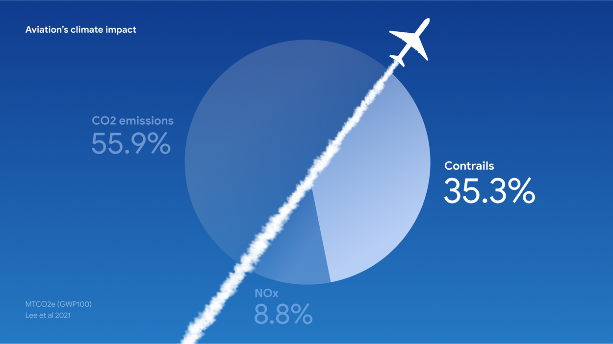
AI is paving the way for making air and ground transportation more sustainable, with reduced carbon emission and improved air quality in our cities. One third of aviation’s climate impact are the result of contrails, the condensation trails sometimes seen behind airplanes. In early real-world demonstrations with partners like American Airlines, our AI-powered forecasts helped pilots reduce contrails by 54%. We’re now making these AI-powered forecasts available across the aviation industry through our Contrails API and working with partners like EUROCONTROL to integrate the forecasts into their flight planning systems. Google.org is providing 3 million dollars to co-catalyze a new nonprofit with Breakthrough Energy, called contrails.org, which will focus on translating research into tangible tools for aviation.
For ground transportation, we’re teaming up with cities to improve traffic flow. Project Green Light uses AI and Google Maps driving trends to propose adjustment to traffic light timing in order to reduce vehicle gas emissions, also resulting in improved air quality. Green Light has demonstrated potential to reduce stops at intersections by up to 30% and reduce emissions at intersections by an average of over 10%.
Conclusion
Our breakthrough research over the past years is already having a profound impact on natural disaster preparedness. Yet, this is just the beginning of what’s possible. We are confident that advancing AI and scientific research can play a key role in addressing the difficult problems of timely, reliable global predictions, working towards better climate resilience. I am incredibly optimistic that collectively we’ll ultimately get closer to a point where no one is surprised by a natural disaster coming their way.
Other posts of interest
-

April 9, 2026
ConvApparel: Measuring and bridging the realism gap in user simulators- Generative AI ·
- Machine Intelligence ·
- Natural Language Processing
-
April 8, 2026
Improving the academic workflow: Introducing two AI agents for better figures and peer review- Generative AI ·
- Natural Language Processing
-

April 3, 2026
Evaluating alignment of behavioral dispositions in LLMs- Generative AI ·
- Human-Computer Interaction and Visualization ·
- Machine Intelligence


