Geospatial Reasoning: Unlocking insights with generative AI and multiple foundation models
April 8, 2025
David Schottlander and Tomer Shekel, Product Managers, Google Research
We’re introducing new geospatial foundation models and bringing them together with Geospatial Reasoning, a research effort that uses generative AI to accelerate geospatial problem solving. This can unlock powerful insights for crisis response, public health, climate resilience, commercial applications, and more.
Quick links
When you get the best route from Google Maps, explore a new place in Street View, look at your neighbourhood on Google Earth, or check the weather forecast with Search, you’re using geospatial data. For decades, Google has organized the world’s geospatial information — data associated with a specific geographical location — and made it accessible through our products.
Geospatial information is essential in everyday situations and for a wide range of real-world enterprise problems. Whether you’re working in public health, urban development, integrated business planning, or climate resilience, Google’s data, real-time services, and AI models can accelerate your analyses and augment your proprietary models and data.
Geospatial information can be big, complex and hard to understand — just like the real world! Gathering, storing and serving data requires specialized sensors and platforms. Observations of the things you care about can be scarce or require time-consuming labelling. Use-cases are diverse and often require various kinds of data that need to be aligned and cross-referenced (weather, maps, images, etc.), and recent breakthrough AI methods are not optimized for geospatial problems. Transforming geospatial information into understanding is a focus area for Google Research.
Last November we introduced two pre-trained, multi-purpose models to address many of the challenges of geospatial modeling: the Population Dynamics Foundation Model (PDFM), which captures the complex interplay between population behaviors and their local environment, and a new trajectory-based mobility foundation model. Since then, over two hundred organizations have tested the PDFM embeddings for the United States and we are expanding the dataset to cover the UK, Australia, Japan, Canada, and Malawi for experimental use by selected partners.
We’re also exploring how generative AI can reduce the significant cost, time, and domain expertise required to combine geospatial capabilities. Large language models (LLMs) like Gemini can manage complex data and interact with users through natural language. When integrated into agentic workflows that are grounded in geospatial data, we’re starting to see that they can generate insights in various domains that are both surprising and useful.
Today, we're introducing new remote sensing foundation models for experimentation alongside a research effort called Geospatial Reasoning that aims to bring together all of our foundation models with generative AI to accelerate geospatial problem solving. Our models will be available through a trusted tester program, with inaugural participants including WPP, Airbus, Maxar, and Planet Labs.
An overview of Geospatial Reasoning.
Grounding with geospatial foundation models
Our newest remote sensing foundation models are based on proven architectures and training techniques, such as masked autoencoders, SigLIP, MaMMUT and OWL-ViT, and adapted to the remote sensing domain. All models were trained on high-resolution satellite and aerial images with accompanying text descriptions and bounding box annotations. These foundation models generate rich embeddings for images and objects, and can also be fine-tuned for specific remote sensing tasks, such as mapping buildings and roads, assessing post-disaster damage, or locating infrastructure. The flexible natural language interface provided by the models supports retrieval and zero-shot classification tasks, allowing users to, for example, find images of “residential buildings with solar panels” or “impassable roads”.
We evaluated the foundation models on a broad range of remote sensing benchmarks, covering classification, segmentation, and object detection tasks. We performed evaluation using frozen model features and with both fine-tuned and zero-shot setups, with promising results showing state-of-the-art performance on multiple metrics. Furthermore, we used these models for multiple remote sensing efforts across Google (including disaster response and mapping urban and agricultural landscapes) and they consistently showed improvement on task metrics. We plan to share more details about the models and evaluations in the coming months. Organizations can inquire about access to test these models on their own use cases through our trusted tester program.
Research into Geospatial Reasoning
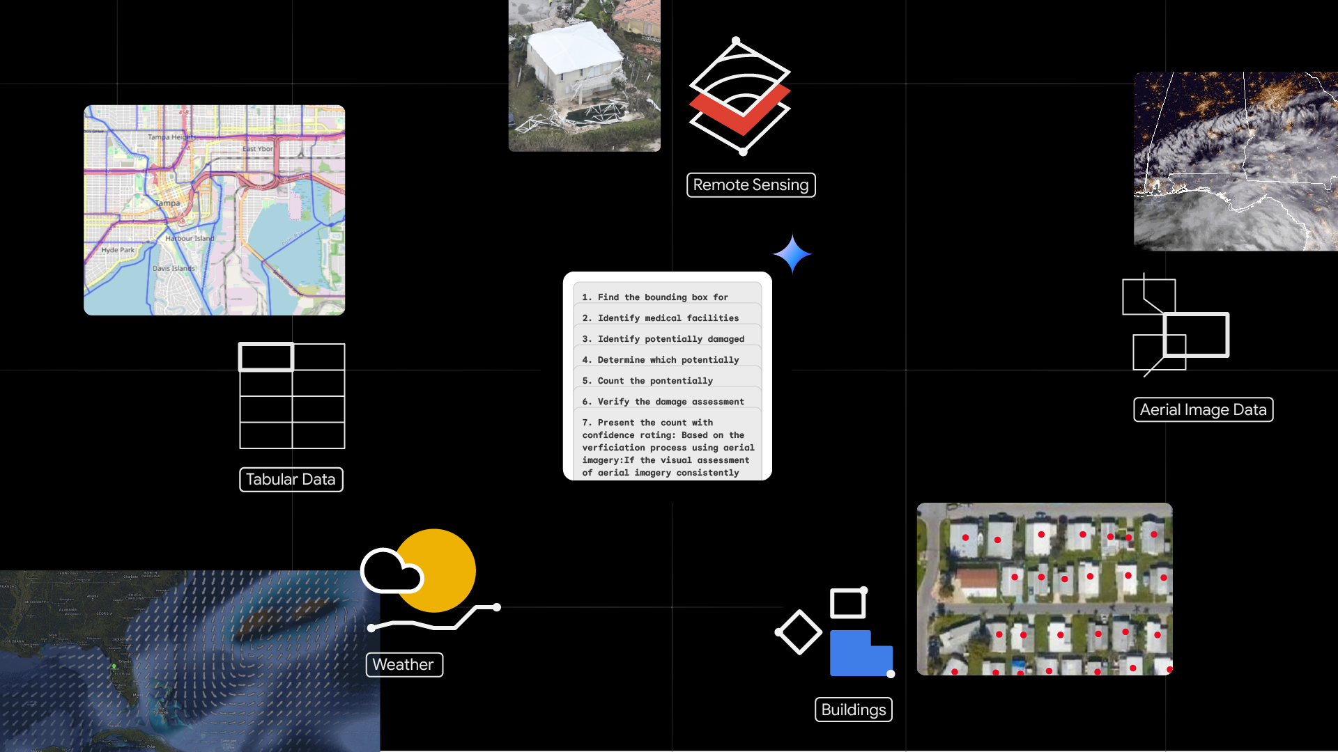
Geospatial Reasoning, our newest research effort, is a framework for building agentic workflows that will allow developers, data analysts, and scientists to integrate Google’s most advanced foundation models, discussed above, with their own models and datasets. Last October, Google started piloting Gemini capabilities in Google Earth, using Gemini to create unique data layers, conduct GIS operations and derive geospatial insights — accelerating geospatial analyses in Google Earth’s no-code environment. Geospatial Reasoning will extend this approach by demonstrating how developers can build bespoke workflows on the Google Cloud Platform to handle intricate geospatial queries using Gemini.
Gemini will orchestrate inference and analysis across Google’s models and datasets, the user’s proprietary sources, and public domain data sources. Given a complex natural language query, Gemini will plan and enact a chain of reasoning, analyzing multiple geospatial and structured data sources, and using advanced AI models for task-specific inference and grounding. Responding with insights and data visualizations, Geospatial Reasoning will provide rapid, trustworthy answers.
For example, here's how a crisis manager responding to the aftermath of a hurricane could use Geospatial Reasoning:
- Visualize the pre-disaster context in open-source satellite imagery using Earth Engine.
- Visualize the post-disaster situation by importing their own or externally sourced high-resolution aerial imagery.
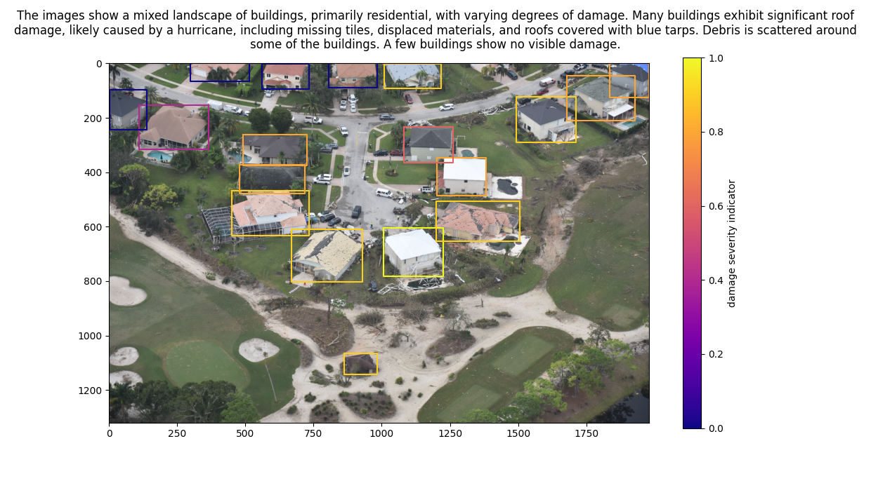
- Identify areas where buildings have been damaged or flooding has occurred, with inference grounded in analysis of aerial images by remote sensing foundation models.
- Call our WeatherNext AI weather forecast to predict where risk of further damage is likely.
- Ask Gemini questions about the extent of the damage, including:
- Estimating the fraction of buildings damaged per neighborhood.
- Estimating the dollar value of property damage, based on census data.
- Suggesting how to prioritize relief efforts, based on the social vulnerability index.
Demonstration app built with Geospatial Reasoning framework. The video has been edited for brevity.

Example agentic workflow initiated by Geospatial Reasoning: A high resolution image for the area of interest is retrieved from Google Cloud Storage; Gemini then calls the specialized OWL-ViT remote sensing model for object detection using a prompt such as, “Find the buildings in this image.” The response is a list of bounding box coordinates (box boundaries added for visual comprehension). Image patches are then sent to Gemini or a task-specific captioning model for building damage assessment and the responses are summarised. The final result is illustrated in the caption above the image.
How Geospatial Reasoning works
The demonstration application was built using the Geospatial Reasoning framework made up of several distinct components:
- A packaged Python front-end application that integrates mapping and graphing components and provides a chat window user interface,
- An agentic back-end that implements a LangGraph agent deployed using Vertex AI Agent Engine,
- LLM-accessible tools for accessing Earth Engine, BigQuery, Google Maps Platform and Google Cloud Storage, performing routine geospatial operations, such as translating between natural language and geospatial geometries, and using remote sensing foundation model inference endpoints deployed on Vertex AI.
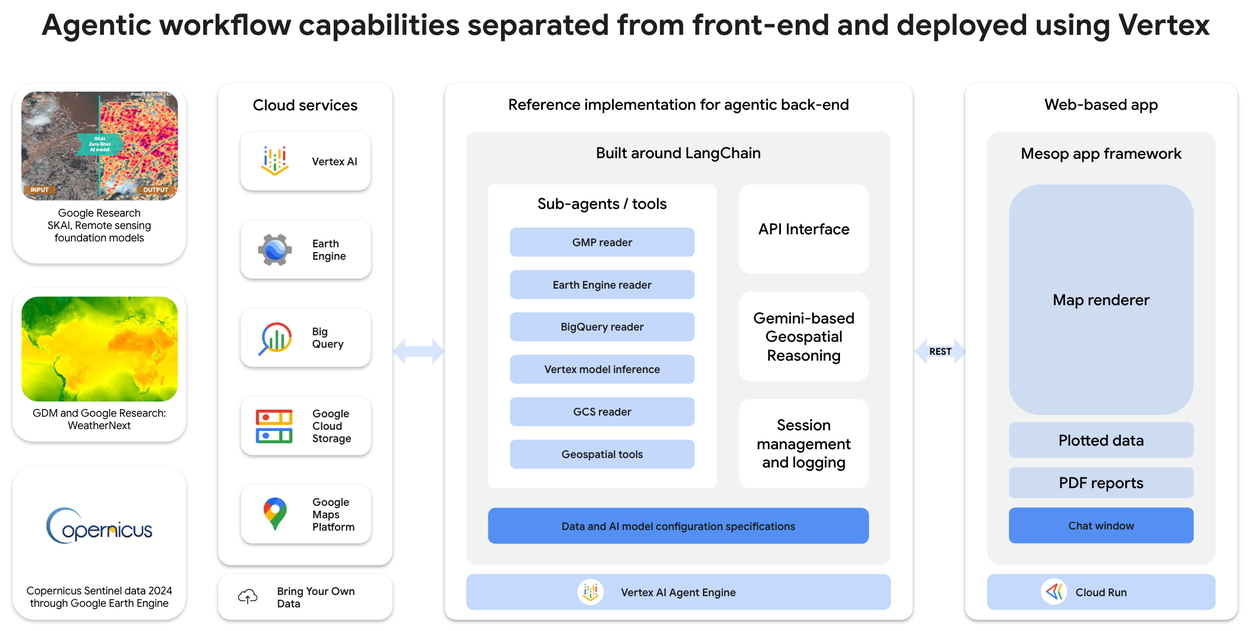
High level architecture of the Geospatial Reasoning framework used in the example application.
In the example application, we’ve illustrated how this approach can be applied to post-hurricane damage assessment. The application was configured with access to high resolution aerial images from the Civil Air Patrol, which were pre-processed using AI capabilities (geolocation and identification of critical and key infrastructure), from Bellwether, X’s moonshot for Climate Adaptation. We used Google Research’s Open Buildings and SKAI models to pre-compute building detections and damage assessments using NOAA flight images in order to run the example application in real time, since even a county-scale area of interest can have hundreds of thousands of buildings or more. To enrich the analysis, we incorporated social vulnerability indices, housing price data, and Google WeatherNext insights.
Let’s think bigger, together
Geospatial Reasoning, grounded with our new geospatial foundation models, will be able to simplify and accelerate real-world problem solving. While Geospatial Reasoning is still under development, both Population Dynamics Foundation Model (PDFM) and our remote sensing foundation models are available now through our trusted tester program.
We are excited to share that Choreograph, WPP's global data and technology company, will be integrating PDFM with WPP’s proprietary media performance data and insights to pioneer its AI-driven audience intelligence, using these deep behavioral signals to enhance media planning and activation.
We are also thrilled to announce that Airbus, Maxar, and Planet Labs will be the initial testers of our remote sensing foundation models.
Airbus has been pioneering the commercial Earth observation imagery market for nearly four decades through innovative technology. The company is planning to utilize Google's remote sensing foundation models, empowering users to extract insights from billions of satellite images faster than ever before.
Maxar is a leading provider of precise geospatial insights. Maxar brings together its satellite imagery and AI-enabled software platforms to maintain a “living globe” that provides access to the ground truth in near real-time. They are planning to use the remote sensing foundation models to help customers interact with, and extract faster mission-critical answers from, this “living globe”.
Planet Labs is a leader in Earth observation, providing daily satellite imagery and geospatial solutions. Planet Lab's data helps businesses and governments make better decisions. They will use the remote sensing foundation models to simplify and accelerate insights for their customers.
You can learn more about this work by visiting our website and completing this form to receive updates on our progress, including announcements about new offerings, and opportunities to join our trusted tester program.
-
In addition to Google Research’s efforts, new geospatial analytics datasets from Google Maps Platform and Earth Engine, integrated directly into BigQuery, were also announced at Cloud Next ‘25. Learn more here.
Quick links
Other posts of interest
-

April 9, 2026
ConvApparel: Measuring and bridging the realism gap in user simulators- Generative AI ·
- Machine Intelligence ·
- Natural Language Processing
-
April 8, 2026
Improving the academic workflow: Introducing two AI agents for better figures and peer review- Generative AI ·
- Natural Language Processing
-

April 3, 2026
Evaluating alignment of behavioral dispositions in LLMs- Generative AI ·
- Human-Computer Interaction and Visualization ·
- Machine Intelligence